


The Global Peatland Database
The Global Peatland Database (GPD) is a project of the International Mire Conservation Group (IMCG) located and maintained at the Greifswald Mire Centre.
The GPD collates and integrates data on location, extent and drainage status of peatlands and organic soils worldwide and for 268 individual countries and regions. The database contains analogue and GIS maps, reports, observations, pictures, and is supported by the Peatland and Nature Conservation International Library PeNCIL. The GPD regularly produces integrative analyses including biennial worldwide overviews on peatland status and emissions and provides science-based, policy-relevant spatial information for:
- climate change mitigation and adaptation;
- biodiversity conservation and restoration;
- and sustainable land use planning.
News Global Peatland Database online
Global Peatland Database online
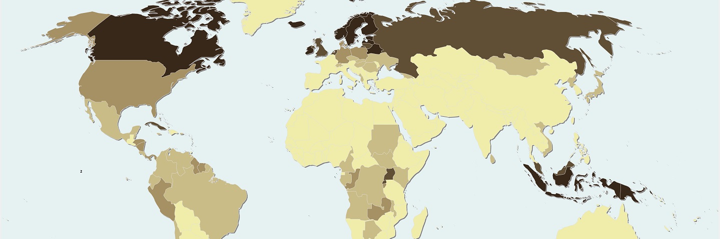
19/12/2024 Here, we provide the new Global Peatland Map 2.0 (GPM 2.0) using a bottom-up approach on the basis of >200 datasets in the Global Peatland Database compiled from multiple data sources over the last decade, along with our own field mapping campaigns to fill some major data gaps.
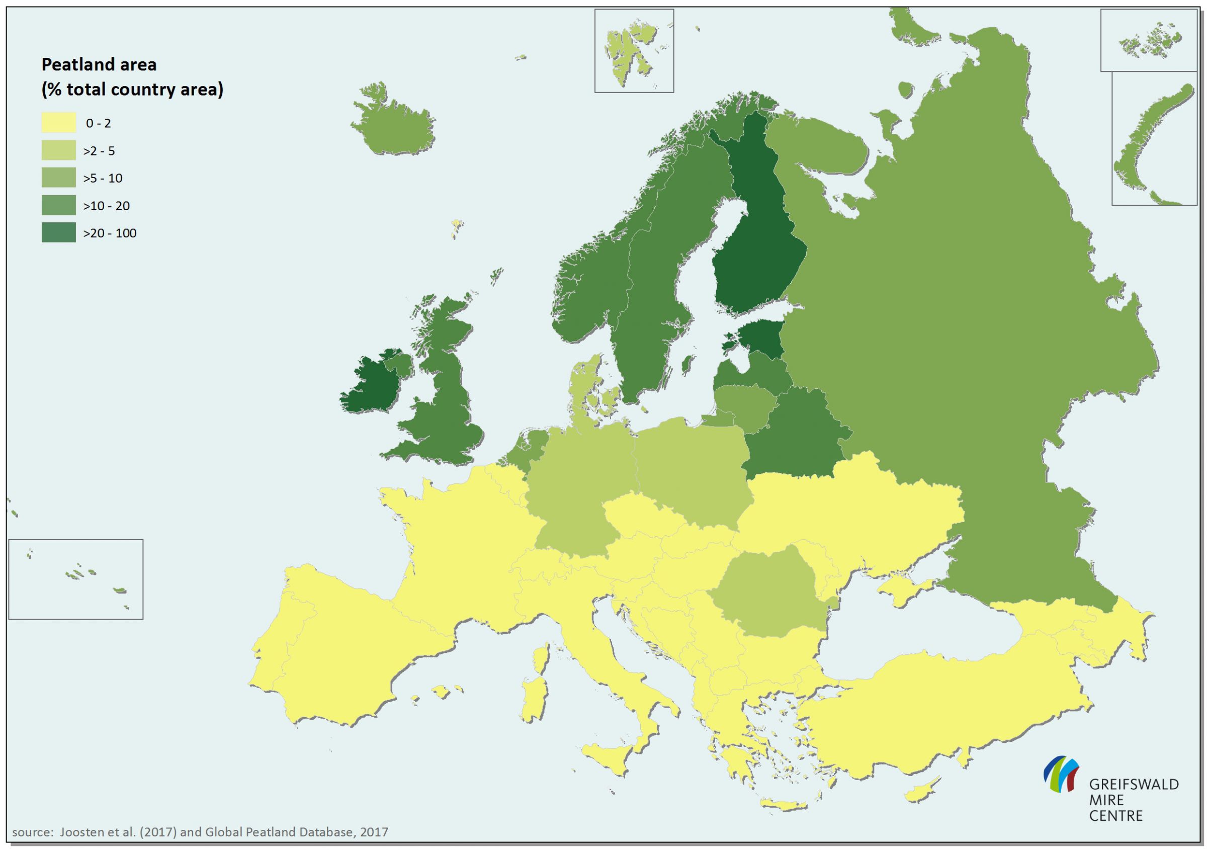
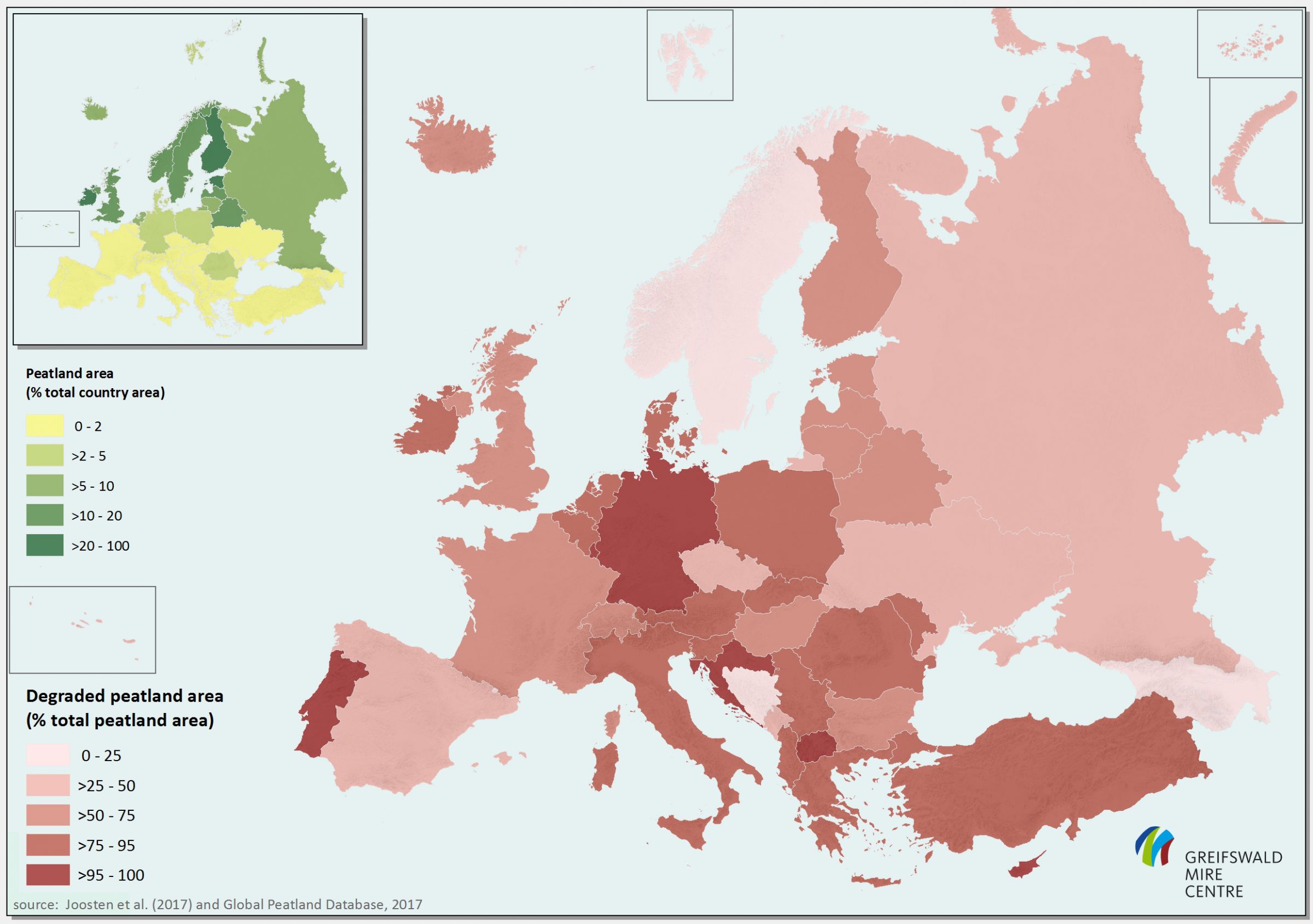
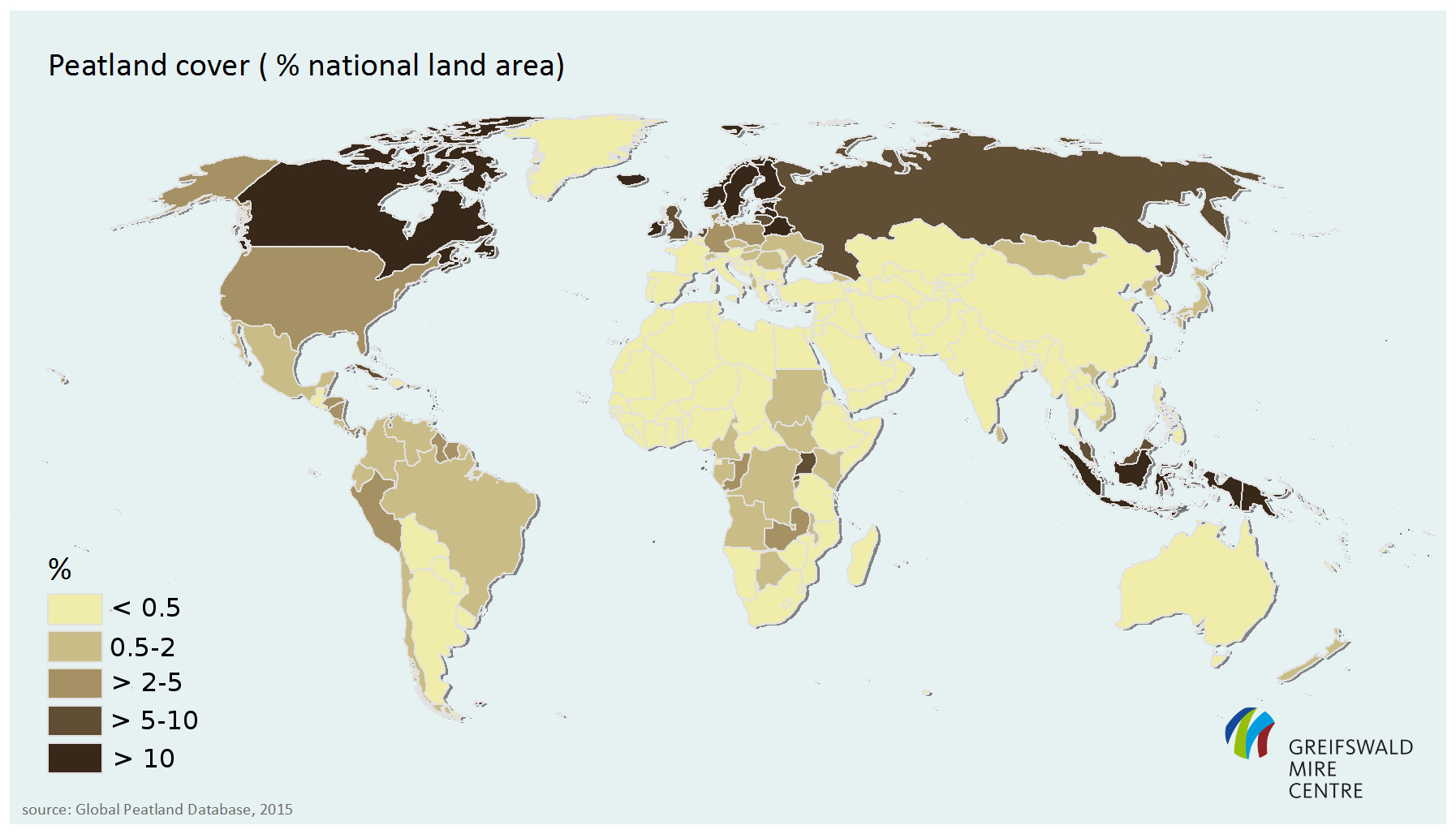
The GPM 2.0 was further updated during the development of the UNEP Global Peatlands Assessment in 2022. The GPM 2.0 covers 3.72 million km² ('peat dominated' land) and 2.08 million km² ('peat in soil mosaic'), for a total of 5.8 million km² of global peatlands in a 0.5 km x 0.5 km grid while using an inclusive definition of peatlands. Of this global peatland area, 42% is located in North America, 32% in Asia, 10% in Europe, and the remaining 16% across South America, Africa, Central America and the Caribbean, and Oceania.
The new map provides a more comprehensive and accurate coverage of global peatlands in a more systematic manner than earlier global peatlands maps. The Global Peatland Map 2.0 is freely downloadable in a 1 km x 1 km grid ().

For World Wetlands Day: New European Wetland Map!
02/02/2025 Just in time for World Wetlands Day a new European Wetland Map shows Europe's peatlands, floodplains and coastal wetlands more comprehensively than ever before in one map. Compiled from about 200 data sources, this map informs policy makers, land users and anyone interested in wetlands not only about their distribution and types, but also, for example, about potential areas at risk of flooding. Users can freely download the European Wetland Map, published in a collaboration with the projects ALFAwetlands, WET HORIZONS and Building a European Peatlands Alliance, for their own analyses. A vector dataset on the geographical distribution of the wetlands considered is available on a country basis in an ArcGIS geodatabase as well as a country-specific high resolution Geo-TIFF collection (grid size: 1 arcsecond).
Background: The World Wetlands Day (WWD)
This day has been drawing attention to the importance of wetlands, including peatlands, on February 2nd every year since 1997. The Ramsar Convention, the international agreement for the protection of wetlands, was adopted on February 2nd in 1971. Since 2021 the WWD has been recognized as an international day by the United Nations. Therefore, their restoration and protection is important. Due to pollution, drainage and agriculture, fires and overfishing, wetlands, which include peatlands, are under threat worldwide or have already been destroyed. Yet they are guarantors of biodiversity and climate protection. Among other things, wetlands offer people protection from drought and flooding, purify water and regulate the microclimate. In Germany, 95% of former wetlands have been drained and are no longer recognizable as such today.
Contact
General issues:
|
Senior researcher, coordinator of the GPD |
 |
Regional issues:
|
Senior researcher |
 |
|
Senior researcher & Director of the GMC |
 |
|
Senior researcher |
 |
|
Junior researcher |
 |
|
Junior researcher |
 |
|
Junior researcher |
 |
|
Junior researcher |
 |
|
Junior researcher
|
 |
History
The Global Peatland Database started in the 1990s as a project of the International Mire Conservation Group (IMCG) with the aim to elaborate a worldwide overview of the occurrence of peatlands, with references and background information. The necessity of such overview emerged from the development of IMCG/IPS Wise Use guidelines, in which the first global overview was published.
The 8th Conference of Contracting Parties of the Ramsar Convention (Valencia, November 2002) adopted Guidelines for Global Action on Peatlands (GGAP, see page 21 of the IMCG/IPS Wise Use guidelines) to provide a framework for worldwide initiatives for peatland wise use, conservation and management. These guidelines recommended the establishment of a global database of peatlands and mires with baseline information on their distribution, size, quality, ecological characteristics, biological diversity, and stored carbon.
Facing that challenge, the Global Peatland Database (GPD) is today located at the Greifswald Mire Centre, coordinated by Dr. Alexandra Barthelmes and continuously developing and improving.
Following the 2009 milestone publication ‘The global CO2 picture’ by Hans Joosten, since 2012 the database is transferred and extended into spatially explicit geodata. In 2021, the Global Peatland Map is being prepared in collaboration with UN Environment and the Global Peatlands Initiative.
Methods
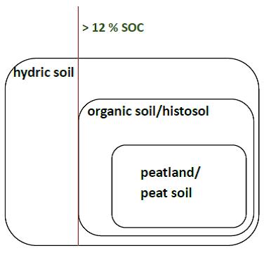
No globally accepted definition for ‘peatland’ exists. Various English terms (mire, marsh, swamp, fen, bog …) are used for naming different mire and wetland types (Joosten et al. 2017). To elaborate a global overview on peatlands the GPD includes all soils that fit into the broad IPCC concept of ‘organic soils’ with 12 percent or more organic soil carbon without a depth criterion (Hiraishi et al. 2014). This automatically includes almost all peatlands, histosols and other organic soils, and allows the use of diverse, historically grown national or regional datasets.
Common terms and definitions for ‘peat’ and ‘organic soil’
Peatlands belong to the organic soils (histosols), which also include soils with shallower organic layers, less organic matter, and a sedimentary origin (FAO 2015). (Undrained) organic soils again belong to the ‘hydric soils’ (wetland soils; USDA, NRCS 2003).
Varying with country and scientific discipline, peatlands have been defined as having a peat layer from 20 to 100 cm, whereas also the minimum content of organic matter of the ‘peat’ varies similarly across definitions (Joosten et al. 2017). However, many national approaches require “peatland”’ to have a minimum peat depth of 30 cm and ‘peat’ to have >30% (by dry mass) of sedentarily (=on the spot) produced organic material (Joosten & Clarke 2002, Parish et al. 2008, Rydin & Jeglum 2013).
The Intergovernmental Panel on Climate Change (IPCC) considers ‘organic soils’ to be soil with at least 12 to 18 percent of organic carbon, depending on the clay content (IPCC 2014). This definition encompasses all peatland and other organic soils, but has no criterion for the minimum thickness of the organic layer to allow countries to use their country-specific definitions, often historically determined.
Proxy data for the indication of peatlands and organic soils
Detailed geospatial data on location, extent and drainage status of peatlands are rare and highly variable with respect to concepts, terms, completeness and accuracy. The Global Peatland Database (GPD) aims to fill knowledge gaps and to speed up peatland mapping and inventory.
Gaps in the coverage of geospatial peatland data can partially be filled by using ‘proxy data’, i.e. (mainly abiotic) features which indicate the possible occurrence of peatlands.
- Bedrock: alluvial and lacustrine sediments and areas;
- Relief and landforms indicating a surplus of water: depressions; floodplains and backs swamps along rivers; tidal flats and lagoons along coasts; high altitude gently sloping mountain valleys and volcanic plateaus; regular domes with con- and eccentric patterns such as raised Sphagnum bogs and tropical Peat Swamp Forests;
- Soils: hydromorphic, wetland, swamp and mangrove soils, muck or highly organic soils;
- Wetlands: long-term water logged areas;
- Vegetation: mangroves, salt marshes, grass and sedge dominated floodplains and valleys, freshwater broad-leaf forest (‘Peat Swamp Forest’), palm forest, Afro-alpine Moorlands and Andean Paramos;
- Land use: areas where agriculture is hampered by water logging, poor drainage, or inundation, or with regular anthropogenic drainage infrastructure.
Integration and evaluation of geospatial peatland data
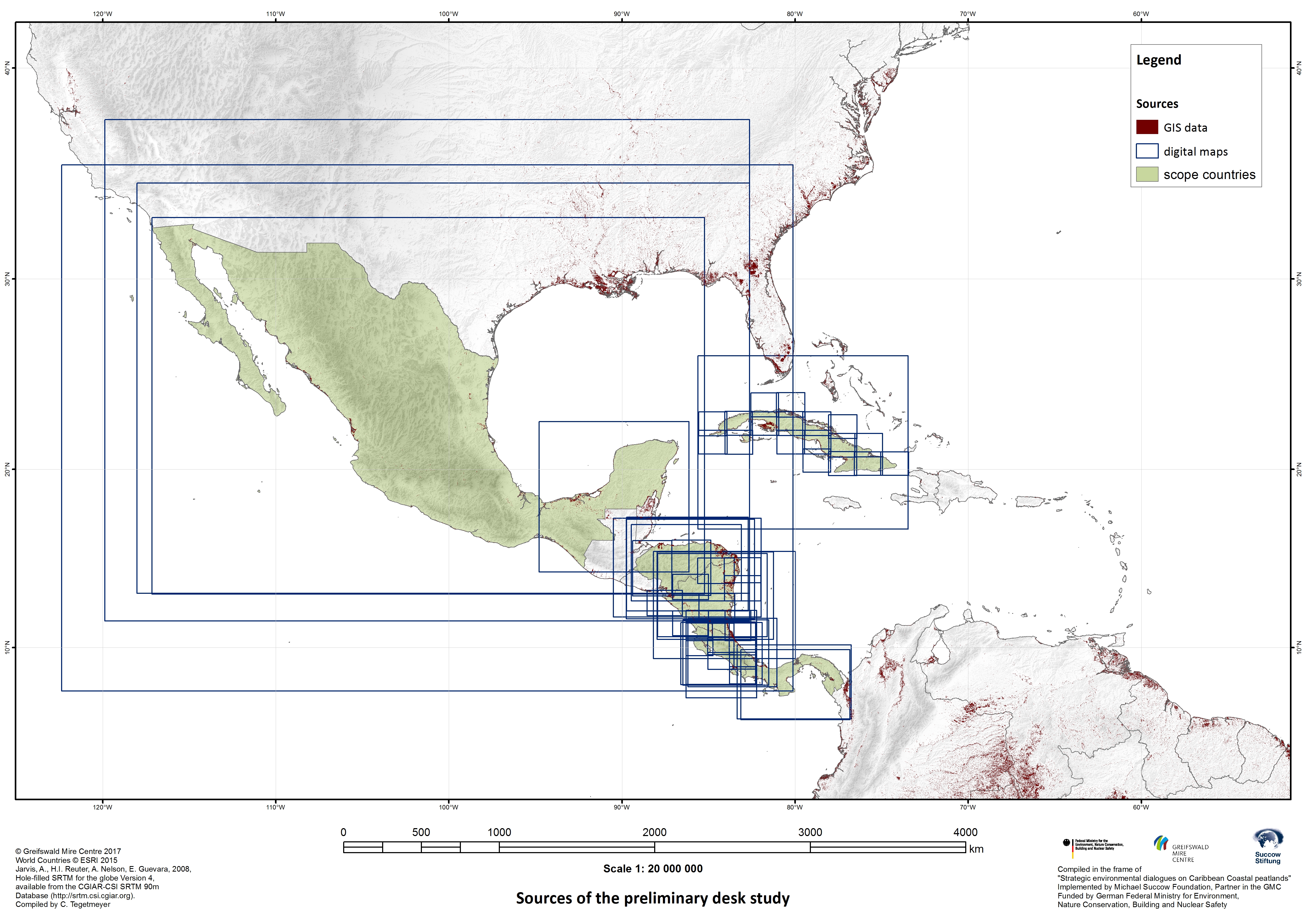
The first product using this approach was “Peatlands and climate in a Ramsar context”. The GPD collects geospatial peatland data, analyses terms and concepts used, and evaluates their completeness and accuracy, using expertise of GMC members and international partners. The collated data are integrated in GIS to a hybrid, ‘bottom up’ peatland map with global coverage.
High resolution mapping of peatlands and organic soils
Despite rapidly developing remote sensing technology, peatland mapping still faces major problems:
- All remote sensing approaches need sufficient ground data for calibration and validation, but geo-referenced soil profiles from peatlands with adequate carbon content analysis are scarce.
- Major proxies for identifying peatlands by remote sensing are lost when peatlands are deforested or drained. Assessment of peatland occurrence in landscapes altered by humans therefore often requires the use of historical satellite imagery, that only goes back to the early 1970s with resolution decreasing the further back one goes in time.
- Peatlands are diverse and used in very different ways. This hampers simple extrapolation of results and requires high resolution mapping.
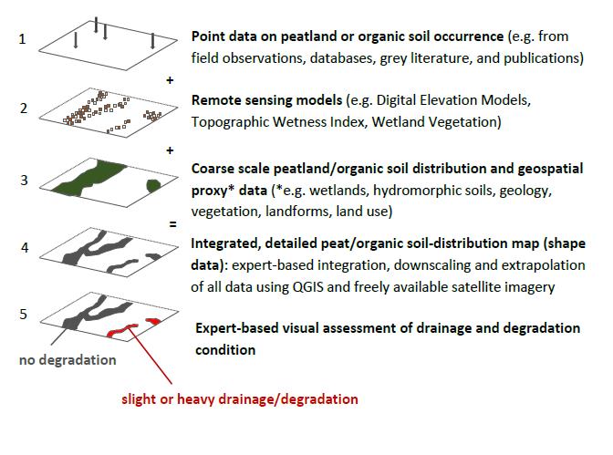
We therefore developed an expert-based, manual, rapid, high resolution peatland mapping approach which delivers ‘peatland probability maps’, using available field data, specialized knowledge, and modern techniques (see the scheme of the mapping process below). The approach links various science networks, methodologies and databases, including those of peatland/landscape ecology for understanding where and how peatlands may occur, those of remote sensing or identifying possible locations, and those of soil science (legacy soil maps) and (palaeo-)ecology for ground truthing.
Products
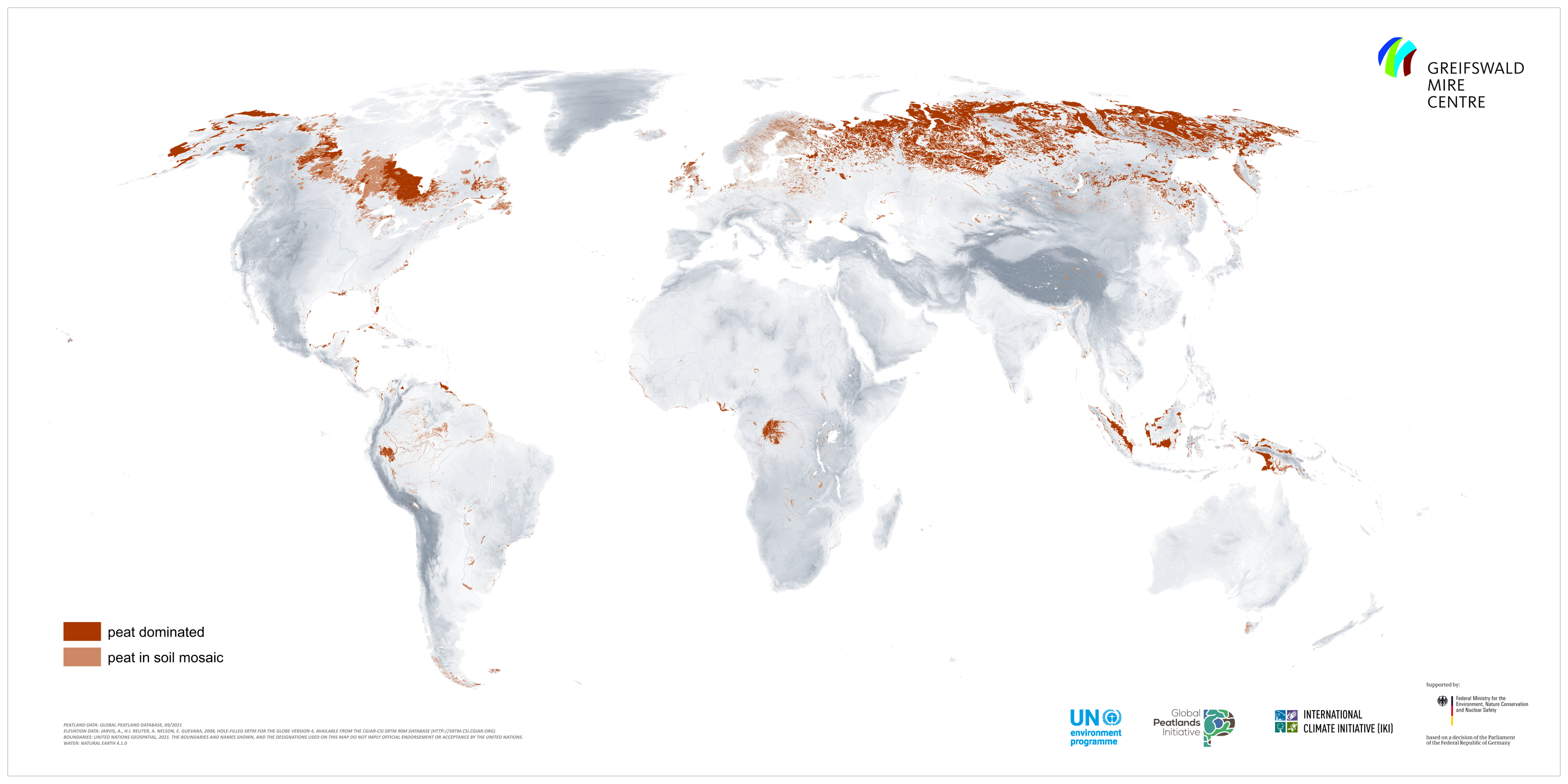
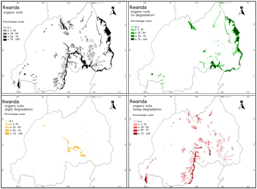
The world's peatlands are important ecosystems for the global water balance and crucial for mitigating climate change. For this, knowledge about their global distribution is essential. Using information from the Global Peatland Database, we have developed the Global Peatland Map over the last decade by compiling more than 200 datasets in a bottom-up approach and using our own field mapping campaigns to fill some important data gaps. This map was further updated during the development and publication of the UNEP Global Peatlands Assessment (2022). We are aware that this map overestimates peatland distribution in Indonesia and Malaysia, which we aim to adjust in our next update. Please note that despite the tremendous progress these maps provide, mapping peatlands remains an urgent task for many regions and countries of the world.
The corresponding geodata are available here as a Geotiff dataset. The map covers the peatlands of the world in a grid of 1 x 1 km. The dataset has 2 very rough categories: 1=peat dominated 2=peat in soil mosaic. Because of the huge differences between the more than 200 single datasets, these 2 groups do not have any fixed tresholds and are more like a expert judgement to not overestimate peat extent where it interferes with mineral soil types.
You find more information on the map in the UNEP GPA (2022).
More information about the UN environment programme (UNEP).
Additional links for:
Briefing paper: accelerating action to Save Peat for Less Heat!
2021
Mires in Europe—Regional Diversity, Condition and Protection
2020
Aggregierte Karte der organischen Böden Deutschlands
2019
Peatlands of Africa (presentation at the Global Landscape Forum 2019, Accra, Ghana)
Inventory of peatlands in the Caribbean and first description of priority areas
2018
Smoke on water – countering global threats from peatland loss and degradation, a Rapid Response Assessment of UN environment and GRID-Arndal (contribution from GPD in framework of the Global Peatland Initiative)
2017
Distribution and degradation status of tropical peatland types (presentation at the Global Symposium on Soil Organic Carbon 2017, FAO, Rome)
Mires and peatlands of Europe. Status, distribution and conservation
2016
Mapping location, extent and drainage status of organic soils in East Africa (presentation at the 15. International Peat Congress 2016, Kuching, Malaysia)
The contribution of drained organic soils to the globally emitted greenhouse gases and global emission hotspots (presentation at the European Geosciences Union General Assembly 2016, Vienna)
2015
2006
Circumpolar map mires and permafrost (p.4)
References
Rydin H. & J.K. Jeglum (2013). The biology of peatlands. 2. Edition, Oxford University Press, 382 p.
Ongoing and completed projects
“The Global Peatlands Initiative: Assessing, Measuring and Preserving Peat Carbon” (ICI)
“Path to sustainable management of peatlands in North Kalimantan” (GIZ)
“Update of the GMC Global Peatland Map”
“Update of the GMC country-wise emission database and assessment of GHG emissions from peatlands”
“Developing a pantropical peatland map based on eco-zones with substantial peat occurrences”
“Deutscher Moorschutzdialog” (BMUB
“Assessment of Carbon (CO2) emissions avoidance potential from the Nile Basin peatlands” (GIZ)
“Smoke on water – countering global threats from peatland loss and degradation”, a Rapid Response Assessment of UN environment and GRID-Arendal (in framework of the Global Peatland Initiative)
“Scientific and technical Briefing Note on inventories for designating tropical peatlands as Wetlands of International Importance” (Ramsar Convention
‘High resolution GIS-based peatland mapping of East Africa’ (Netherland’s Environmental Assessment Agency
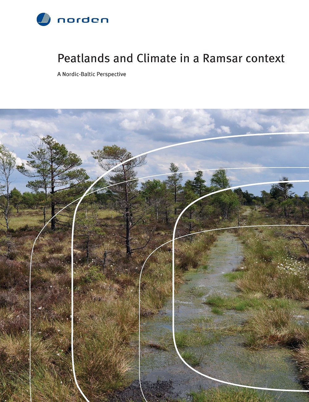
‘Review of the importance of peatlands in the countries within the Nordic Baltic Wetland Initiative for mitigation climate change and potentials for restoration with a reference to designate peatland RAMSAR sites in the region’ (Nordic Council of Ministers)
Current and completed degree theses
PhD:
“Developing a tentative peatland map for the Amazon region” (Cristina Malpica)
„Analyse von Moordegradation und -trajektorien mit raum-zeitlich hoch aufgelösten Satellitendaten“ (Farina de Waard)
“A first assessment of the potential distribution of peatlands in Uzbekistan” (Leonie Hebermehl, 2021)
“Identifying and mapping peatlands in the high altitude areas of South Sudan” (Rayan Madani, 2021)
“Organic soils in national inventory submissions of EU countries” (Nina Martin, 2021)
“Mapping of the Venezuelan peatlands” (Cristina Malpica, 2019)
“The global distribution of peat fires – causes, current hotspots and future trends” (Farina de Waard, 2019)
“Mapping of coastal peatlands in the Caribbean region: Columbia and Costa Rica” (Laura Villegas Mejía, 2018)
„Moorvegetation als Proxy für Treibhausgas-Emissionen“ (Moritz Kaiser, 2018)
“Remote sensing based mapping of the Popondetta peatland, Papua New Guinea” (Felix Beer, 2018)
„Naturraumkundliche Untersuchungen in Kubanischen Küstenmooren“ (Christoph Schaller, 2014)
Citation
If not specified otherwise, please cite our products as follows:
Based on data from the Global Peatland Database / Greifswald Mire Centre (year)